Saturday 27 October 2012

River Rea; Cannon Hill Park - Cartland Road

This walk is a pleasant route from Cannon Hill Park back towards Cartland Road. There is the familiar route marker near the lake, and the path leads away past a play area and a small field. The river is on the right of this path. This section is tarmacked and very popular with cyclists.


Along the way, there are bridges over the river, and also small areas that look like old crossing points. It is possible to go to the waters edge but some of the bricks are worn so be careful!


The path branches off in a fork - going up the path on the left takes you to Moor Green and King's Heath. The path to the right takes you along the river towards Stirchley.


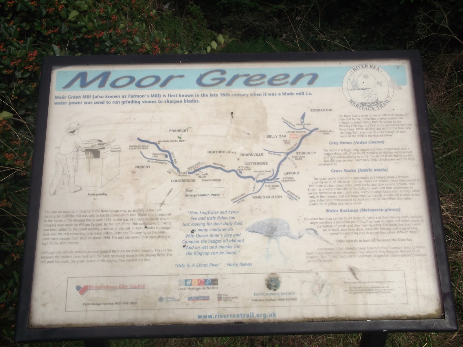
The road suddenly stops, and you need to cross a bridge to continue the walk. The river is now on your left, and there is open fields to your right. I never knew this was here, it was quite a surprise when I came across this sign! Another of the 150 or so mills used to stand on this site; Moor Green Mill was a blade sharpening mill, powered by the water from the river.


At Kitchener Road, you must leave the river and walk along the footpaths. This is a residential area and it is the main route, be aware of cars, cyclists, joggers etc. If you walk up this road, you will end up on the Pershore Road. If you take a left onto Cecil Road, you will come out at the end of Dogpool Lane (another mill stood here). Take a left, and cross the road. Just before Dads Lane Chippy, there is a path, and this is the River Rea route again.


The route now follows a simple path, also fully tarmacked, through to Cartland Road. You can continue your walk on the other side of the road or you can detour into Stirchley and visit their newest residents!


Heron :)


Thursday 25 October 2012

University of Birmingham Blue Plaque; Charles Lapworth


"University of Birmingham. Charles Lapworth, undertook pioneering work into the formation of mountain belts, 1882-1883"

He also went crazy doing so.

The Earth Sciences student society is named LapSoc (Lapworth Society) in his honour, though this is routinely changed with some sort of pun for their socials (Lashworth, Lapizza, Lapsausage etc.) The Museum is also named after him.

This plaque can be seen on the wall of the Lapworth Museum of Geology at the University of Birmingham, main campus.

Sunday 21 October 2012

Canal Walk; Tunnel Lane – King’s Norton Junction


This route starts at Lifford Lake, or it can be started from Lifford Lane. Follow the sign on a lamp post for the River Rea Heritage trail. When you get to Lifford Lake, follow the lane to the right. Follow it all the way round, you will go past some derelict warehouses and then end up on the canal tow path! Turning right takes you towards the guillotine lock; turning left takes you into unchartered territory… or up towards the Maypole.


This is a relatively short walk and the towpath is suitable for all types of users. There are often cyclists down here so be prepared to move aside. 

Wednesday 17 October 2012

Lickey Hills Toposcope


The Lickey Hills Country Park is found approximately 10 miles to the south west of Birmingham City Centre. The land is wholly owned by Birmingham City Council but it isn’t actually in Birmingham! The Lickey Hills  are in fact in Bromsgrove, and the park was gifted to the people of Birmingham in the late 1800s.


The toposcope, which can be found at the top of Beacon Hill offers extensive views across Birmingham. At 975ft above sea level, you can see all the way to South Staffordshire Pennines in the north; Dudley to the northwest; Cannock Chase to the east and over to Birmingham Airport in the southeast. Behind the toposcope, now obscured by trees, you can see to the Cotswolds and sometimes into Wales. It’s a pretty humbling place to be, seeing the land stretching out for miles in all directions!


The Lickey Hills toposcope is quite elaborate, and resembles a small fort. I think the actual toposcope is the metal plate at the top of the fort, and the fort was just built to house it as a centenary celebration. If you can confirm or deny this, get in touch!

Some panorama pictures can be seen here. And here are a few photos I took while I was there a few weeks back:


I got the bus to the 47 terminus and then walked the rest of the way - it is about a mile and a half from the terminus to the beacon. I have doodled over a Google Earth screengrab to highlight key places. The 98 bus also goes up here (I made a booboo and put 92 on the picture); it stops near to The Old Hare and Hounds before turning off to head towards Rubery.


I have marked on BIG HILLS because I'm pretty certain they weren't that steep when I was younger. Good for the thighs though. There is a car park near to the beacon; it is on Monument Lane. There is also a car park at the golf course on Rose Hill, and at the visitor centre on Warren Lane. Bins are few and far between, please take rubbish with you, and please clean up after your dog!

The Lickey Hills are close to the hamlet of Lickey, which dates back to 1225.


Saturday 13 October 2012

Birmingham's Mills


It may be hard to imagine looking at the Rea when it is in normal flow that this river once supported nearly 200 mills! These mills included corn grinding mills, fulling mills, paper making and blade sharpening. The most famous mill is probably Sarehole Mill.

The River Rea flows through Birmingham, from the Waseley Hills in the south west to the River Tame, under Spaghetti Junction. The river is also fed by the River Bourn, which flows through Stirchley, and the Bourn Brook, which flows through Selly Oak, amongst a few others.


As the Rea supported so many mills, people became protective over the water. When the canals were built, competing companies stole each other’s water and sometimes, water was taken from the river to top up the canal network. As a result of this, several pools were built, near the river, and these acted as compensation pools, to ensure the river always had water. Examples of these include Wychall Reservoir and Lifford Lake.

Some mills have remains which can apparently be seen along the river. This includes Northfield Mill which I covered way back when I first started this blog – see here – though I couldn’t see any trace of the mill when I walked the route!


The picture below illustrates the number of mills on the Birmingham river systems, which includes the rivers Rea, Cole, Blythe and Tame. The Rea starts in the bottom left corner and works its way up towards the Tame.


Thursday 11 October 2012

The Saracen’s Head, King’s Norton


The Saracen’s Head on King’s Norton Green is part of a medieval complex of buildings which includes the Old Grammar School. It was a winner on BBC’s ‘Restoration’ program in 2004 and is now known as St Nicholas Place.


It was built as a Tudor Merchants House in 1492, and in 1643 Queen Henrietta Maria of France may have stayed here during the Civil War on her way up to York. The Saracen’s Head is supposedly haunted by the ghost ofthe Queens maid, who caught influenza from the troops who were camped by the stream (the River Rea, near to The Camp pub).

The venue is now fully restored and can be hired out for events – I used to give blood here – and there is also a cafĂ©, and I believe tours are available. There is a piece of original wattle and daub in the upstairs room too!


King’s Norton Green is part of the King’s Norton ConservationArea and there is also a monthly farmers market on the Green. This is quite a delightful little place to just sit and watch the world go by, or to explore, or to use a base for your next adventure! It is near to many locations I have already blogged about – the canal; Lifford Lake; the River Rea; King’s Norton Nature Reserve and hopefully soon many more!


Tuesday 9 October 2012

Canal Walk – Mary Vale Rd to Lifford Lane


I like the canal system in Birmingham. I used to cycle along it quite often with my brother and father, from Northfield to Selly Oak and back. One day soon I hope to pluck up the courage (and get my wheels straightened) and then embark on a bike ride! But until then I shall make do with walking. This route took me from Bournville railway station in Stirchley to Lifford, where I left the towpath to go and find Lifford Lake.  The route continues towards King’s Norton junction along the Birmingham and Worcester Canal. This short stretch of canal featured on a BBC show, Canal Walks, with Juila Bradbury.

To get onto this part of the canal, I walked up Mary Vale Road from Stirchley high street (Pershore Road). The way onto the towpath is indicated with a purple arch; it also the way into platform 2 of the railway station. There is an information board about transport in Stirchley and the panels on the barrier also have etchings. When you get to the bottom of the ramp, turn back on yourself so you go under the bridge.


This is a nice walk, away from the hustle and bustle of Stirchley high street. I saw geese, ducks and a heron when I walked it. It is a relatively level route and is well surfaced. I encountered a few cyclists on my walk so be prepared to move aside! Fishing is not allowed down here due to the overhead wires for the trains and local power station.


There is a small bridge to cross, when you go under the next bridge which takes the Pershore Road over the canal. The bridge for the canal runs alongside and slightly below the main pedestrian bridge so you do not need to go onto the highway to cross the canal. There are some steps to allow access to the main road, or you can go down the slope and continue along the canal.

At Lifford Lane, I left the canal network. If you choose to carry on, the towpath (now on the other side of the canal) will take you down to the King’s Norton Junction, where the Stratford Upon Avon Canal joins. Turn left at the junction to see the guillotine lock, continue straight on to get to Wast Hills tunnel, or turn right to go through King’s Norton Park.


The above picture shows the underside of the bridge that carries Lifford Lane over the canal. This is where I left the towpath. The towpath continues on the other side towards King's Norton Junction, or you could leave here and find Lifford Lake.