Showing posts with label Conservation. Show all posts

Wednesday, 4 September 2013

Weoley Castle

Weoley Castle is an area of South Birmingham which has the remains of an old fortified manor house. Not much remains of the house, but the bases of the stone walls can be seen. There’s more to see here than at Hawkesley House!

Weoley Castle is not a castle as such; it was a manor house that had curtain walls and a moat and it was inhabited since the 12th century. You can read more about the history here or there is a very comprehensive history here.


Covert shot taken through the railings ;-)


Unfortunately, Weoley Castle ruins are closed off to the public except on open days and guided walks. There is a ‘Talk and Walk’ Day on September 7th that I’ll be going to!  The walls can be seen from a viewing platform (and some can be seen from the track that goes along the back of the site, as I discovered by accident!) Weoley Castle is operated by the Birmingham Museums Trust.

A few more pics, from around t'interwebs:

Source

Source

Weoley Castle can be found on Alwold Road, B29. The 29 bus goes past the site, from Northfield high street, or the City Centre (by St Phillips Cathedral/Pigeon Park). Maybe I'll see some of you at the Talk and Walk day on September 7th?

Saturday, 17 November 2012

Hawkesley Hall; King’s Norton


One day, I was doing a volunteering shift at Stirchley Stores with a rather nice man called Steve. We were talking about this blog and he asked if I knew anything about Hawkesley Hall. I said, I’ve never heard of it, which was true. Fast forward a few weeks to a day when I decided to go and find it, and I’m quite pleased that I have! There are no remains on the site, so if the signs weren’t here you’d have no idea. There are carved stone blocks with minimal information on, but to someone who doesn’t know, this area just looks like a patch of trees in the middle of an estate.


Hawkesley Hall is possibly the sister manor to Hawkesley House on Turves Green – the former being Little Hawkesley and the latter being Great Hawkesley. There is a chance that the former was the first home of the Hawkeslow family, and then they upgraded and moved to Turves Green. I wish I could claim to be a genius and know all this, but a lot of my information is from here and here.


There is a path around this site, and it supposedly follows the line of the moat. I like this idea; you can walk around the perimeter of the property before taking the path that would lead up to, and now through, the house.


It would be very interesting to know more about this – what the original house would’ve looked like, what the surrounding area would look like, how the Victorian house that was built on the same land would look like etc. I love peering into the past at old buildings and imagining how the world has changed so much in that one location!


Lime Tree Walk


To get to this location, you need to aim for the Hawkesley Estate. I walked up from the canal, but the 45 stops a 5 minute walk away, and the 35 and 27 also stop nearby. Once again, check out my brilliant Google Earth Map to find out more!


Thursday, 1 November 2012

Bournville Village Green


Bournville is a suburb in south Birmingham, about 4 miles from the city centre. The original area of Bournville is centred around a village green with amenities such as places of worship, shops and open parkland for recreation. The original layout remains to this day, and the area is now a designated conservation area.


The village green, surrounding parkland and houses were all planned and built by the Cadbury brothers (George and Richard), who were the sons of John, founder of the Cadbury business. The brothers built the Cadbury factory which is next door to the green.


The Cadbury brothers believed that workers needed a suitable place to live and work, close to the factory, but with large, spacious houses and clean air. The area of Bournville reflects this; houses are semi-detached 3 or 4 bedroom buildings, with large gardens. The land along the river was opened out into parkland, the canal network provided links to the countryside, and at the time, this part of Birmingham was in the countryside anyway, not the modern urban sprawl we are used to. You can read more here, here and here. You can see some pictures here.

Bournville Village Green was the centre of this masterpiece, with a Carillion, a Quakers meeting house,  and local shops including a butchers and a bakers. There are also schools in the area.


I love walking around the Green – it feels very nostalgic and is really quite nice when it’s sunny! All of the buildings retain their original character, and the sounds from the Carillion carry for quite a distance. You can get to the village green area in a number of ways. The 27 and 11 bus services serve this area well, and you can also catch a train to Bournville and then walk up Bournville Lane (follow the signs for Cadbury World). You could also walk or cycle along the Worcester and Birmingham canal, exiting at Mary Vale Road (also the exit for the railway station). You can also drive, though parking during the week is limited.

There is also an information board to tell you more:


Bonus Pics:


Saturday, 13 October 2012

Birmingham's Mills


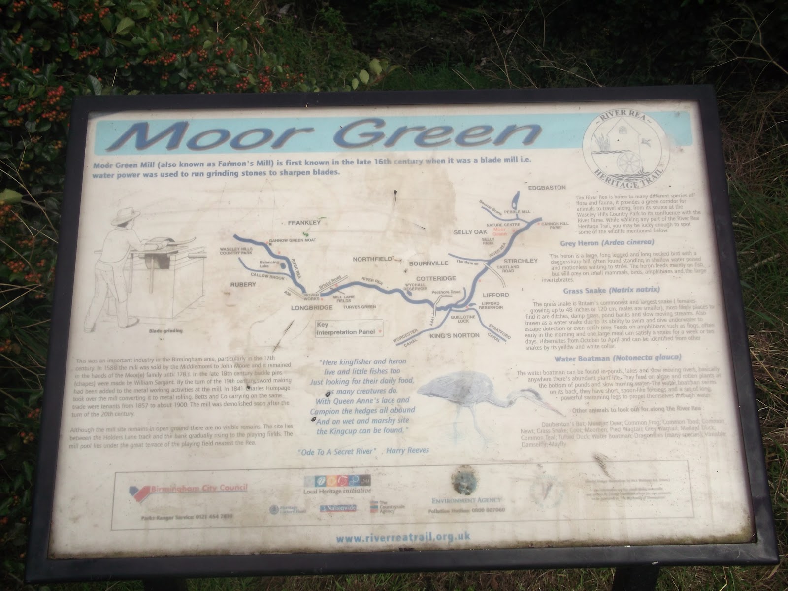
It may be hard to imagine looking at the Rea when it is in normal flow that this river once supported nearly 200 mills! These mills included corn grinding mills, fulling mills, paper making and blade sharpening. The most famous mill is probably Sarehole Mill.

The River Rea flows through Birmingham, from the Waseley Hills in the south west to the River Tame, under Spaghetti Junction. The river is also fed by the River Bourn, which flows through Stirchley, and the Bourn Brook, which flows through Selly Oak, amongst a few others.


As the Rea supported so many mills, people became protective over the water. When the canals were built, competing companies stole each other’s water and sometimes, water was taken from the river to top up the canal network. As a result of this, several pools were built, near the river, and these acted as compensation pools, to ensure the river always had water. Examples of these include Wychall Reservoir and Lifford Lake.

Some mills have remains which can apparently be seen along the river. This includes Northfield Mill which I covered way back when I first started this blog – see here – though I couldn’t see any trace of the mill when I walked the route!


The picture below illustrates the number of mills on the Birmingham river systems, which includes the rivers Rea, Cole, Blythe and Tame. The Rea starts in the bottom left corner and works its way up towards the Tame.


Saturday, 29 September 2012

Rednal Tram Terminus


The Rednal Tram Terminus is exactly as the name suggests; a terminus for the old Birmingham tram network! Trams used to come down the Bristol Road from the City Centre and take people to the Lickey Hills in Bromsgrove for their holidays. The old terminus building is still standing. Use has changed over the years from public toilets to varying restaurants (it is now a Cantonese takeaway).

Around the back of the building, there is a section of old cobbled street, and inlaid in the cobbles are two sections of track, which come to a point at one end. These are the remains of the tram tracks! Some of the cobbles are covered with grass but most of it is uncovered. There are no signs telling you what these are, which I think is a shame. The other end of the tram lines is in the city centre, by the Gas Hall.


Thursday, 27 September 2012

Walking for Heritage; More Toilets

...and a viaduct with pieces missing!

Thus post contains two elements, neither of which are on the actual walk guide, but are on the route. I have included them as points of interest as you will see them as you walk the route!


More Toilets
This time, a Victorian public urinal! Gosh I spoil you all don’t I?!

Located on the corner of Great Barr St and Heath Mill Lane, Digbeth, this structure has been closed off from the public. I only know about it and what it is because when I was at college in an attempt to become a plumber, we had a full scale discussion about it!


As far as I know, the inside is just a metal wall which gents can pee against, and some poor Victorian child probably had the job of cleaning it. It is quite a fine metal structure and the detail on the external panels is very decorative. I think it is cast iron. 


Partial Viaduct
This is quite something. This wall, as seen on Heath Mill Lane (if walking from Deritend back towards Eastside), doesn’t look like much. It’s only a wall, right?


Wrong.

Once you step onto the towpath and look back up at it, you will see that it is part of a huge brick built structure, a bridge, that goes across the canal. There are no signs to tell you anything about this, but a look on my old mate Google Earth at this area seems to suggest that this was built for use as a railway bridge! I am not sure if it was ever used to carry tracks through this area. It seems quite strange to knock out the archways over the road sections if it was just built to look pretty.


It is quite a peculiar thing to notice once you know that it isn’t just another really high brick wall! You can read more about them both here.

Thursday, 13 September 2012

Birmingham Coat of Arms

The Birmingham Coat of Arms is a beautiful piece of work; so much colour, so many things to look at, so many elements formed into one item. I  had to do a mini project about it when I was in primary school, and sometimes I'm shocked at how many people who either don't know we have one, or what it looks like. Hopefully this blog will help explain it a bit!

The Coat of Arms is used as a symbol to identify people, families, clans and tribes. They are used today to separate cities (for example, the City of London and the City of Westminster - pretty much the same place [I use this term loosely!], but different coat of arms)

Source

The Birmingham Coat of Arms was first used in 1838 when Birmingham was a borough. It has changed several times, with parts added and colours changed. It is based on the de Bermingham family armorial bearings, and the supporters (the female and male figures on each side) were added in 1899 when Birmingham became a City. In 1976 a new Coat of Arms was adopted, this time incorporating Sutton Coldfield (the Tudor Rose in the crown which commemorates Henry VIII granting a charter to Sutton Coldfield in 1528).

The colours and patterns of the main shield are taken from the City Flag, which can be seen flying from the Council House daily. Parts of the flag date back to 1325. The ermine cross which goes across the shield represents Edgbaston and Sutton Coldfield, and the Bishops mitre in the centre represents John Vesey, Bishop of Exeter, who was born in Sutton and procured the charter from Henry VIII, amongst other things.

Quite a lot of history in our Coat of Arms! You can see it in most places around the City - it features on buildings, road signs and used to be on the buses and rubbish trucks!

You can read more about it here, as well as by following the links in the text.


Sunday, 9 September 2012

Walking for Heritage; Public Toilets!


I have included these on the blog purely as an attempt to show off.

Behind this billboard on the way down Digbeth High Street towards the Custard Factory, is an old block of public toilets! I only know this because it was on the telly a while ago on a programme called Grime Busters (I think, I may be wrong!) and some poor council guy had to go in wearing full PPE and breathing equipment to try and clear up all the pigeon poo!


The only hint at this being a toilet block is around the side (facing the High St) – the blue tiled wall gives it away.


The remains of these toilets can be seen on Digbeth High Street, as you walk from the HMV Institute towards the Custard Factory. You are now entering Deritend, possibly the oldest part of Birmingham.

Wednesday, 5 September 2012

Walking for Heritage; Digbeth Police Station


This blog posts continues the Walking for Heritage route. The previous post can be read here. 

From the Typhoo Tea Factory, follow the route of the walk (Fazeley St, New Canal St, Meriden St, Coventry St, Allison St, Digbeth High Street]. The police station is on the corner on your left. You will also pass a second ‘art house’ on the way.

The Digbeth police station is a grand building, designed by Henry Stilgoe (the City Surveyor) in 1911. I can’t find much more information about its history, which is a shame. If anyone knows of any then do let me know! This police station is still in use today.


As I was walking down Allison St, I saw the police station (pretty awesomely) reflected in the windows of the building opposite! 


One more pic 


Wednesday, 15 August 2012

Walking For Heritage; Typhoo Tea Factory

From the Art House, cross the road to the bridge. The Typhoo Factory is just across the water.

I had no idea Typhoo originated in Birmingham. At all. Some digging around on Ye Olde Interwebs has told me otherwise, and their website is quite a good source of information!

The Typhoo Factory is now empty, but you get a clear view of it whilst on the WfH walk route at the corner of Andover St/Fazeley St. Cross the road to get a better view. This web page has a picture of the Birmingham factory in 1926.


I’m not sure if there is a way to get closer to the building – this is still a very industrial working area. The Typhoo website has quite a lot of detail regarding the origins of this brand!

Monday, 13 August 2012

Birmingham Blue Plaque; William Hutton


City of Birmingham
"William Hutton, Bookseller, the first historian of Birmingham lived on this site from 1772 until 1791"

On the wall outside Waterstones on High St, near the Rotunda.