Showing posts with label River Rea. Show all posts

Sunday, 25 August 2013

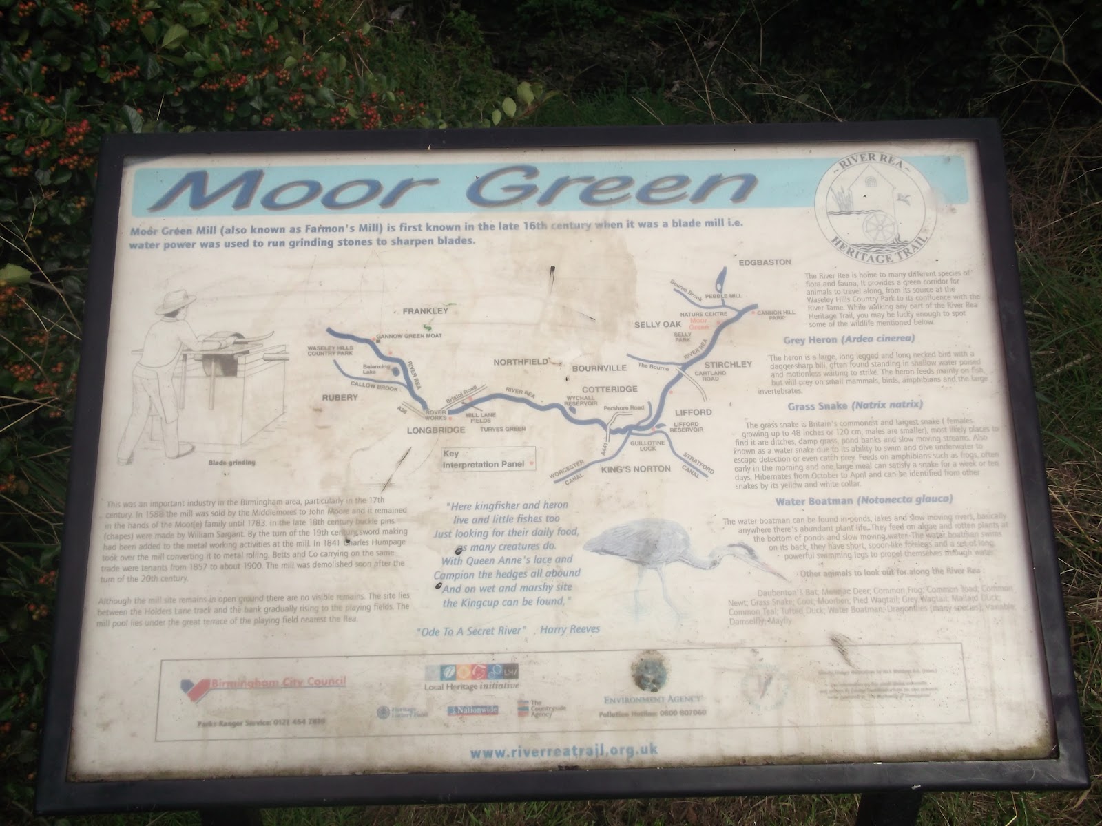
Ode to a Secret River

As many of you will know, Birmingham is home to the wonderful River Rea and its tributaries and wildlife. Not so many people know that it has a poem! This ode was written in 1998 by Harry Reeves, and I believe you can buy hard copies of it at the Lickey Hills Visitor Centre. Parts of this ode are featured on the notice boards along the river.

I've lifted this straight from the River Rea Trail website but I fully recommend you go and have a nosey through it all, lots of information relating to the Rea!


Ode to a Secret River

On Waseley Hills in Worcestershire a little river rises, 
It isn’t much to look at, but it’s so full of surprises, 
To many folk it’s not well known, which seems to be a pity 
For on its banks near Deritend began our Second City. 

The river is of course THE REA which flows into Brum’s heart 
Since Saxon times to present day its played a vital part. 

From Waseley Hills it flows north-east and heads for Gannow Green 
Then Frankley, Rubery, Colmers Farm where Callow Brook is seen, 
On, underneath the Rover Works the Rea makes steady flow, 
To local folk ‘The Austin’ works is still the name they know. 

From Longbridge through to Daffodil Park and then past Kalamazoo, 
The Impey family founded it with loose-leaf binders new. 
Through Mill Lane Fields the Rea flows on, once corn mills graced each end,
‘twas ‘Hawkesley Mill’ near Kalamazoo and ‘Northfield’ by the bend. 

Now underneath the railway line as Northfield comes in sight, 
And by the side of Station Road, Rea flows on day and night. 
Soon on to Wychall reservoir past rolling mill long gone, 
But then Kings Norton Church appears with spire to gaze upon. 

So on to Lifford we must go, cross Worcester Canal with river below, 
Then Tollhouse Junction and Guillotine Lock, 
on Lifford Hall should we dare to knock? 

Another reservoir appears and Lifford is its name; 
‘twas built two hundred years ago and Wychall was the same, 
Canals were being opened up with navvies toil and sweat 
More water still was needed now to keep the levels set. 

Canals did take their water from the nearby River Rea, 
but millers were not happy and protested all the way! 
In the year of seventeen ninety our Parliament passed an Act 
To store supplies of water, which everybody backed 
Those reservoirs provided that water night and day, 
Canalmen now felt happy, as did millers on the Rea! 

To Fordhouse Lane and Hazelwell where corn mill once stood proud 
And on the bank a millstone lies, mid bushes on the ground, 
The walkway and the cycletrack now pass on either side - 
It’s good for people to enjoy a walk or family ride. 

The Pershore Road’s not very far with traffic night and day, 
But as you walk the valley’s banks it’s quiet by the Rea.         

                                      
At Cartland Road the Rea is joined by a stream that’s called ‘The Bourn’ 
It started life as Merritt’s Brook, then Griffin’s Brook was born, 
But as it flowed through Cadbury’s works did George call it the Bourne? 

Through Stirchley now to Selly Park where Moor Green Woods are seen 
With joggers and ‘doggers’ and mothers with prams, enjoying the peaceful scene, 
Here kingfisher and heron live and little fishes too 
Just looking for their daily food, as many creatures do. 
With Queen Anne’s lace and Campion the hedges all abound 
And on a wet and marshy site the kingcup can be found, 
Whilst Himalayan Balsam, is this the Ranger’s friend? 
Just springs up as you walk the banks, on going round a bend. 

What is that in the distance?, that building I can see 
Ah, now I know, It’s Pebble Mill and the well known BBC, 
I wonder if Carl Chinn is there, still getting little rest. 
But telling all the world around that Brum is still the best! 

The Nature Centre’s our next stop, as we go on our way 
And here another little stream runs down to join the Rea. 
This is Bournbrook and not the Bourne. To some it seems confusing 
But as it flows past Pebble Mill the brook finds this amusing. 

Inside the Nature Centre, it’s fun for many a child, 
The animals can’t stray away, but do still roam quite wild. 
There are fox and lynx and beaver, with sheep and goats and deer, 
While birds, and snakes, and insects are studied without fear. 

In nineteen hundred and twenty seven a thunderstorm did break, 
It was a summer’s evening , the ground looked like a lake, 
The Rea was flooded all the way from Longbridge into town 
And streets turned into rivers, as the rain came pouring down. 

In Austin works and Kalamazoo the floods did leave their mark 
And bread and milk were brought by boat to folk in Selly Park, 
Allotments in the valley had sties where pigs were kept 
But when the river burst its banks the pigs down stream were swept. 
Near Bristol Road at Longbridge, a man in a hut was found, 
The hut was wedged beneath a bridge, but he was safe and sound!


The Cricket ground was flooded with water from the Rea, 
And pictures in the local press showed bike sheds washed away! 
But now there is a cover, ‘Brumbrella’ is its name, 
It takes the water from the pitch - down in the Rea to drain! 

Deep into a culvert the Rea had to go 
Because of that flooding so long ago, 
Between its stone walls into Cannon Hill Park 
With weirs to flow over to make it less stark. 
But the walls are not barren to those who are keen 
For if you look closer moss and lichen are seen. 

Louisa Ryland gave the park in Eighteen Seventy Three, 
Its brought much joy to many folk, and most of the time it’s free. 
The flowers and trees are beautiful, at all times of the year, 
But if you walk back through the park, wild meadows soon appear. 

The MAC is busy everyday, with Drama, Theatre, Art 
While August brings a fireworks show and music plays a part. 
There are horse parades and puppet shows, boating and fishing too, 
Whenever you go to Cannon Hill, there’s something to see and do. 

Now it’s under the road into Warwickshire’s ground 
For Edgbaston cricket the crowds are all bound, 
There’s a stand by the river, ‘Rea Bank’ WAS its name 
But it’s now Eric Hollies, of late bowling fame. 

Inside its concrete collar the river still flows on 
Through Calthorpe Park to Balsall Heath, 
Where have the ‘ladies’ gone? 
And then we come to Belgrave Road, to the ‘Bristol’ folk can’t go, 
But up the hill the Mosque is seen whilst the Rea is down below. 

So now it’s under Gooch Street that the Rea is flowing on, 
And then on into Rea street with memories long gone. 
For there you’ll find the places where many a workshop stood 
And men did toil with sweated brow - conditions were not good. 
It was the birth of industry when metal trades held sway, 
And if you walk along those streets, you’ll find some there today. 

At High Street Digbeth, long ago, men met to trade and barter, 
And in eleven sixty-six, King Henry’s Market Charter. 

In April sixteen forty-three the Battle of Brum was fought, 
Prince Rupert came down from Camp Hill and caught defenders short. 
He came to punish Birmingham, whose mills were making swords, 
And crossed the Rea at Deritend with all his fighting hordes, 
They overcame defenders there and put them all to flight 
Then up the hill his forces went to set the town alight! 

“Grey willows whispered by the Rea 
where lovers dreamt and children played in clean fields on a summer’s day”. 

‘Twas over the Rea in Floodgate Street where that place was described 
And here we think Beorma’s folk, a pleasant spot espied, 
They settled near the river’s brink with fields and woods nearby, 
Was water from the Rea itself then pure enough to try? 

To people passing up above the Rea cannot be seen, 
It is a secret river , and we try to keep it clean 
But if the Digbeth plans take shape and start to make their way, 
We hope the next millennium will, revitalise the Rea. 

Road bridges could be opened up to let the people see, 
There is a river down below that’s flowing to the sea. 
Now what about a walkway with flowers and plants and trees? 
And wayside pubs and cafes, where folk could take their ease. 

Bird’s Custard Factory still stands there, its front well worth a glance 
But at the back it’s full of life, with art and craft and dance. 
The old Crown Inn’s just up the road now looking very well, 
If its past history was revealed what stories it could tell. 

So on we go to Fazeley Street, ‘Grand Unions’ overhead 
You can walk the ‘cut’ to London Town, or take a barge instead! 

Now the Rea is hidden, in a culvert dark and deep, 
But ‘neath the rails of Curzon Street, the river does not sleep. 
It flows on to the Heartlands where life begins anew 
Canal banks are now lively, with buildings bright and new. 
Perhaps I’m only dreaming with hope still in my heart 
But could the Rea itself be raised, to play a vital part? 

Spaghetti now looms nearer, it’s just by Nechells bend 
The river is still flowing on, but near to journey’s end. 
At last the River Tame is reached , which takes us to the Trent, 
Due North it flows to Humberside, its waters nearly spent, 
And now it turns towards the East, it’s plain for all to see - 
The Rea’s arrived at journey’s end, out in the Great North Sea. 

From humble start in Waseley Hills, the Rea has reached the sea, 
But on its way as you have heard, its shaped Brum’s history! 

We formed a conservation group, to make all folk aware 
The City has a river and it’s there for ALL to share. 
It has a pleasant valley too with walks and cycle tracks; 
We’ve planted trees and bushes there, and filled up litter sacks. 

We try to make it greener, and help to keep it clean 
But cans and cars and trolleys are dumped upon the scene, 
There is a linear walkway, and cycling’s made its mark - 
One day, we hope, it will become, Rea Valley Country Park!


Harry Reeves 1998


Sunday, 27 January 2013

Local Explorer Walk - Rea Valley Circular


I walked this route on a lovely, sunny, freezing cold day in December, following a route in the Local Explorer Walks booklet. I started at Fairfax shops, but the route can be started anywhere. The booklet states that the walk is 13km (8 miles) long, but after walking it and tracking it with Endomondo, and then working it out on Google Earth, I can confirm it is a little over 5 miles long, which is 8km. Ish. (Therefore I assume the leaflet has a typo!)

The Fairfax area is a relatively new area of Birmingham – this area was still farmland in the 1940s – and it is mainly low rise flats with some blocks. There is a row of shops, which is where I started the walk. They also sell white Kit Kat chunkys, so it’s worth knowing ;-)

From Fairfax shops, I followed the route North, simply because it was going away from the sun and it would be more pleasant. Follow the road towards the pub, then turn right. This road takes you towards the Fordrough. Head up here towards West Heath Park.


You will then pass through the Fairway – this area is also covered on the previous LEW I did, though this time I missed out Merecroft Pool due to recent weather conditions, and I walked down the road towards Wychall Lane, and then onto King’s Norton Nature Reserve.


If you have been following this blog from the start you will recognise this part of the route. Follow the Rea through King’s Norton Nature Reserve, past Wychall Reservoir and up the back of Staple Lodge Road. You will emerge onto Middlemore Road, near Northfield Railway Station. You now want to follow the route of the railway line – another side note, the chippy on the corner here does a hog roast every Saturday – down Station Road. Go under the railway bridge and then immediately cross the road. There is a small gate on the left – this takes you along a river path called the Mill Walk, which (incidentally) was one of my first posts on the blog! There is a small flight of steps here, or you could carry on up the road to bypass these. Just before the steps is a notice board about the mill that once stood here. Apparently there are remains of the building in all the undergrowth but I’ve never seen it!


This is a 4-way traffic light controlled junction with no proper crossings for pedestrians. Take care crossing here!


This part of the walk is pretty much straight along the river now. Take care when crossing near the ford, and continue walking towards the new estate. This part of the path is now the Daffodil Path, and will take you to Tessall Lane.


Follow the road around to the left and up alongside Longbridge railway station. At the junction turn left, and walk up Longbridge Lane. Keep heading in this direction until you pass a park on the left – you’re nearly at the end!


 Follow the road to the left, and this will lead you to a path, which in turn leads you back to Fairfax shops and the lovely chippy! (What! You need a reward after that walk..)

Saturday, 27 October 2012

River Rea; Cannon Hill Park - Cartland Road

This walk is a pleasant route from Cannon Hill Park back towards Cartland Road. There is the familiar route marker near the lake, and the path leads away past a play area and a small field. The river is on the right of this path. This section is tarmacked and very popular with cyclists.


Along the way, there are bridges over the river, and also small areas that look like old crossing points. It is possible to go to the waters edge but some of the bricks are worn so be careful!


The path branches off in a fork - going up the path on the left takes you to Moor Green and King's Heath. The path to the right takes you along the river towards Stirchley.


The road suddenly stops, and you need to cross a bridge to continue the walk. The river is now on your left, and there is open fields to your right. I never knew this was here, it was quite a surprise when I came across this sign! Another of the 150 or so mills used to stand on this site; Moor Green Mill was a blade sharpening mill, powered by the water from the river.


At Kitchener Road, you must leave the river and walk along the footpaths. This is a residential area and it is the main route, be aware of cars, cyclists, joggers etc. If you walk up this road, you will end up on the Pershore Road. If you take a left onto Cecil Road, you will come out at the end of Dogpool Lane (another mill stood here). Take a left, and cross the road. Just before Dads Lane Chippy, there is a path, and this is the River Rea route again.


The route now follows a simple path, also fully tarmacked, through to Cartland Road. You can continue your walk on the other side of the road or you can detour into Stirchley and visit their newest residents!


Heron :)


Saturday, 13 October 2012

Birmingham's Mills


It may be hard to imagine looking at the Rea when it is in normal flow that this river once supported nearly 200 mills! These mills included corn grinding mills, fulling mills, paper making and blade sharpening. The most famous mill is probably Sarehole Mill.

The River Rea flows through Birmingham, from the Waseley Hills in the south west to the River Tame, under Spaghetti Junction. The river is also fed by the River Bourn, which flows through Stirchley, and the Bourn Brook, which flows through Selly Oak, amongst a few others.


As the Rea supported so many mills, people became protective over the water. When the canals were built, competing companies stole each other’s water and sometimes, water was taken from the river to top up the canal network. As a result of this, several pools were built, near the river, and these acted as compensation pools, to ensure the river always had water. Examples of these include Wychall Reservoir and Lifford Lake.

Some mills have remains which can apparently be seen along the river. This includes Northfield Mill which I covered way back when I first started this blog – see here – though I couldn’t see any trace of the mill when I walked the route!


The picture below illustrates the number of mills on the Birmingham river systems, which includes the rivers Rea, Cole, Blythe and Tame. The Rea starts in the bottom left corner and works its way up towards the Tame.


Saturday, 1 September 2012

Lifford Lake, King's Norton

A hidden gem! I found it on Google Earth, and then proceeded to hunt it out and find it. And boy, did I find it! This is another wondrous place – it is surrounded by industry (the Lifford household recycling centre is a stone’s throw away) and there are no signs from the road that make it obvious. I found my way there from Lifford Lane – take Tunnel Lane (signposted as the River Rea Heritage Trail), and Lifford Lake is straight up this road. There is a small car parking area, and then the following sign is visible:


The space opens out to reveal a large body of water – this was once a compensation lake for the nearby mill (which you passed as you walked up Tunnel Lane – this is now on private land, but you can see the buildings from the gate, as well as the sandstone folly). Lifford Lake was built in 1815 and is popular for fishing. I took a panoramic photo while I was there.


You can read more about Lifford here.

Pics taken by me, August 24th 2012. They are up on Flickr!


Saturday, 7 July 2012

King's Norton Nature Reserve & Wychall Reservoir


This post (and route!) follows on from this one which ended at Popes Lane, KN.

This walk along the river takes you through the King’s Norton Nature Reserve, from Popes Lane, past Wychall Reservoir and up to King’s Norton Park. The start point (or, where I started the route from as a continuation of my river walk) is indicated by three signs. There is a body of water in this area, I’m not sure how deep/how full of weeds it is, but be wary of this and ensure children don’t go running off.


The route is well maintained and is flat and tarmacked, so is suitable for all users. There are benches along the way. The river Rea is on your right and the reservoir is up ahead on the left. Despite being quite close to a busy school, an estate and a main road, this parkland is really quiet and you can hear all sorts of birds. More often than not, I spot herons on the reservoir!


This is quite a brief walk, and when you reach a short access road, turn left and pick up the route through the park. When you get to an opening, with a choice of two routes, take the one on the right in this picture. This will lead you past an industrial site, towards The Camp pub and Westhill Road. I'm not entirely sure where the gate on the left leads to..!


There are not many bins along this route; please take rubbish and dog waste with you. There is no parking, or visitor centre facilities. This part of the route is accessible by foot and bike, and the bus route 47 is nearby!

Photos from my walk (taken by me on June 9th) are now up on the Flickr page!

A few more piccies: