Friday 29 June 2012

River Rea; Cartland Road – Dacer Close

Another section of the River Rea for this blog post, this time in reverse. I started my walk at the Cartload Road entrance to Hazelwell Park and walked along the River back up towards Lifford. The route here is tarmacked and suitable for cyclists, walkers, wheelchair users, roller bladers.. whoever!


This is a family friendly park; there is a play area, benches and goal posts for playing football. There is also a large expanse of grass for running about on. The path follows the river, and there are walkways coming off it, leading to residential areas, play areas and roads.


Continuing along the route, which is still National Cycle Route 5, there are some minor roads to be crossed – King’s Norton has a strong industrial background and the rear of Stirchley high street is dotted with warehouses. The first road is Hazelwell Road. If you bear right and carry on up the road, you come out on Stirchley High Street by the school. To carry on along the river, look out for the sign post and information panel (number 4).


The river is now on your left. This stretch of the route is quite short. It takes you along the back of what could well be a new Asda development. You then come out on Fordhouse Lane. Turning left here would take you towards Kings Heath. This is a busy road and a main bus route – please use the crossing if you are continuing the walk.


The people who sort out these routes do like their marker posts:


The walk along here is also quite short, and it seems as though the river just disappears and the path becomes a cul-de-sac with minimal sign posts. When you come out onto Dacer Close, turning right would take you back to Fordhouse Lane. If you keep to the left and walk up the hill, you will see signs for NCR5 and after a short distance you end up on the canal towpath!


This was quite a pleasant walk to do after work on a Sunday morning, and I didn’t quite expect the canal to be there – I didn’t expect to just walk onto it, literally. The walk along the canal shall be part of another post at a later date.

There are not many bins along the route, please take rubbish and dog waste with you. Please use crossings at road junctions and be aware of sharing the path with cyclists, joggers etc.

L x


Bonus pics:


All pics were taken by me on June 24th. They are up on Flickr - click for bigger.

Wednesday 27 June 2012

Guillotine Stop Lock, King's Norton Canal


I haven’t been down the canals in quite a while. The other day, I walked home from work (Stirchley), along the river and eventually the canal. At the Kings Norton Junction, I stood on a bridge and watched some narrowboats doing bazillion-point-turns to get around the corner, and then I eyeballed the guillotine lock. I must’ve known about it, but had probably filed it in some dark recess of my mind. I had a stroll down the tow path to take some photos of it. I also had company in the form of some ducklings who followed me along the path, and then in the water. Also, the narrowboat that was doing the bazillion point turn, it was carrying coal! A proper working barge. But then it got stuck in the guillotine lock and started to list. Naturally, I stood and took photos…


The guillotine lock, I have discovered, is a Grade II Listed building, and is the only gate of this form on the canal. It was built in the late 1800s, and is no longer used and so is permanently open. The engineering geek in me quite enjoyed staring at it for a while! You can read some more about it here.


And the mommy duck with babbies :-)


L x

Pics were taken by me, on June 24th. Feel free to nick 'em. More are up on the Flickr page. Click for bigger!

Saturday 23 June 2012

Exploring Birmingham's Heritage - Guest Post


A guest post! Possibly the first of many :-)

This has been written by Rhys Jones, and contains his photos. Links to his websites are available at the end. I was quite keen to showcase this particular stretch of the canals – many Saturdays of my mid-teenage years were spent down here, jumping across the narrower canal sections; walking to and from Robannas Studios and generally mucking around!

I am open to guest posts – just send me an email and we can discuss it further.


EXPLORING BIRMINGHAM’S HERITAGE


Most people are familiar with the glamorous canal area near Broad Street and Gas Street Basin, but the old industrial area of the Birmingham and Fazeley Canal reveals some interesting aspects of Birmingham history. I joined the canal east of the Snow Hill road bridge and walked up a series of 13 locks to the NIA. Parts of the canal are under bridges and large buildings, giving some challenging light conditions for photography.


Although the distance is only just over a mile, I spent quite a few hours walking slowly and taking photographs. One of the most interesting places was the large dark area under Snow Hill Railway Bridge.


The Birmingham and Fazeley Canal was opened in the year of the French Revolution, 1789. In its day it formed part of the main transport artery between the West Midlands and London and was every bit as congested as the M6 motorway is today. Even when the canal company obtained an exemption from the Navigation Acts (which prohibited use of the canals during hours of darkness or on Sundays), enabling the locks to be worked 24 x 7, the problem remained unsolved.

By Rhys Jones


Thanks, Rhys! I hope to blog more about the canal network of Birmingham over the coming months.

Thursday 21 June 2012

River Rea; Middlemore Rd - Popes Ln.


Another blog post based on a walk down the River Rea, this time, from Middlemore Road near Northfield Railway Station, to the start of Kings Norton Nature Reserve & Wychall Reservoir near Popes Lane. This follows on (quite nicely!) from my previous posts ‘Daffodil Walk’ and ‘RiverRea, Mill Lane’. This route is a continuation of the National Cycle Route 5 and starts where this black signpost can be found.


You probably won’t see much of the river from the path unless you actually walk to the edge to find it. The path takes you near to the river, and you can hear it babbling away. The path is tarmacked along the route, and there are also dirt tracks, and sections of grass are mowed shorter to indicate pathways too. People cycle, walk, jog and walk their dogs down here. There is more open space in this part of the park.


After a short distance you will cross a bridge;


And the path continues to the left, although you can turn right (this takes you up to Bridge Piece and a rather large estate). If you go to the left, the river will now be on your left, and the route continues towards Wychall.


Continue walking along the route. Eventually you will come to what looks like the end of the route – to continue, cross the road (you are on Wychall Road) and pick up the route opposite.


This next section is relatively short. It takes you along the back of some gardens, down towards Kings Norton Nature Reserve. There is open land to the west of the path – you can get to this by either walking to the end and turning left down Popes Lane, or by going onto the grassland at the start of the route instead of onto the path. Google Earth/Maps probably explains this better!

The total length of this walk is less than a mile, and is quite a nice walk. You don’t see much of the river but it’s always there. I walked down this way as a means for walking up to Cotteridge. A lot nicer than jumping on the bus!

I shall cover the next part of the walk in a new post.

The path down here is mostly tarmacked, though there are parts that need work (potholes etc.). There are routes off the main path that you could take. Bins are sparse; please take waste away with you. It is a cycle route, so be prepared to share the path!

L x

Bonus Pics:


Tuesday 19 June 2012

Winterbourne House and Garden


I visited Winterbourne House and Garden on June 10th, as part of the University of Birmingham’s ‘Community Day’, with my sister. We had always known about Winterbourne; I have visited the house before, and my sister had a work ‘do’ here a while ago, but neither of us had properly explored the gardens before. (I did a mini blog about the Community Day here)

The entrance fee was £1 for Community Day, it is usually £4 (prices can be seen on their website). The entrance is sited at the end of a driveway; the house is set back from Edgbaston Park Road. One sight that always makes me smile here is the sheer amount of bees on the plants along the pathway! I thought it was lavender bushes, but Winterbourne tells me it is in fact Nepeta.


Inside the house are a few rooms which have been opened up to allow you to explore and get a feel for what the house was like when it was a private residence. As an aside, my Nan used to work for Nettlefold! There is a little train track, some clothes that were worn, old books, tobacco boxes, and all sorts of nooks and crannies to explore.

Outside, there is a terrace where you can sit and have dinner if the weather is fine enough. The terrace overlooks the formal garden, with its’ lawns and flower borders. My sister and I went to explore the garden, so off we went down some steps and under the lime trees.


I then decided to go through a gap in the hedge – what a good decision! It opened up into another part of the garden, with hidey spaces, benches, and bee hives! We decided to stay on the lawns instead of the paths, and carried on:


We then came across a little gem; the woodland garden. I LOVE things like this; it reminds me of going to the Lost Gardens of Heligan a few years ago. It was such a surprise to see this in a Birmingham suburb, it really is somewhere you should all visit!


Here are some pics, though I feel like this blog and the pictures won’t do it justice.


It really is a place to visit to get the feeling yourself. More pics are up on my flickr account, and you can also read more at these links:

And of course, their own website

L x

Pics taken by me and/or my sister, June 10th. Feel free to nick 'em or visit and take your own. Click for bigger.

Sunday 17 June 2012

Old Joe, University of Birmingham


Old Joe is the clocktower at the University of Birmingham’s main Edgbaston campus. I can remember staring at this clock when I was a child, as we went past on the train into town. I can remember knowing that one day I would go to the University of Birmingham and study there. It was also how I knew we were nearly home – look for the clock face illuminated over Selly Oak. I suspect many people still do this today.

I got lost in the area of Bournbrook a few months ago; I saw Old Joe rising through the trees and I ended up finding my way to the Bristol Road. He’s a good egg.

Anyway! Old Joe is a freestanding clock tower, and is quite tall (~100m) and was built without scaffolding, which for the early 20th Century was quite an achievement.


Many students are suspicious of Old Joe – there is a myth (fact?) that if you walk under the tower as it chimes, you will fail your exams. Also, if it chimes 13 you’ll fail your degree. I’ve both stood underneath as it chimed, and heard it chime 13. Guess I’ve got no chance then!

More information can be read here and here. There is a breeding pair of peregrine falcons nesting at the top and they return every year. They can be heard and seen flying around the top of the tower in Spring. The inscription around the edge says;

"THIS TOWER COMMEMORATES THE FOUNDING OF THE UNIVERSITY THROUGH THE INITIATIVE AND ACTIVE ENCOURAGEMENT OF ITS FIRST CHANCELLOR THE RIGHT HONOURABLE JOSEPH CHAMBERLAIN" [Wiki]

As an aside, I read an article that stated the Edgbaston campus was the inspiration for Isengard of LOTR fame – this provided quite a laugh, but I wonder…

L x

Photo was taken by me on June 10th.

Friday 15 June 2012

Birmingham's Parks

I read a little while ago that Birmingham has over 500 parks. I didn't believe this.

The other day, continuing my love of playing with different layers on Google Earth, I took these two screengrabs. The first is a zoomed out shot of Brum, with roads. The green outlined things are parks & golf courses, or at least the ones big enough to be seen. The second screengrab is the same view, sans roads, but with labels to help you find your nearest park, in the broadest sense. You may be better off looking at your local area map!


Click for bigger. Screengrabs taken June 8th.

It's actually a surprise seeing this much green space in our City. I knew of quite a few.. West Heath, Kings Heath, Cannon Hill, Cotteridge, Kings Norton parks etc., but I never imagined this many.

Who wants to join me in a mission to visit them all?!

L x

Wednesday 13 June 2012

Tram Lines in the City

A short post this time, to show a few pictures. These are remains of the old tram lines that ran into the City - they can be found between the back of the Council House and the Birmingham Museum (Gas Hall), on Edmund Street.


You can read more here.

Pics were taken by me, May 30th. Feel free to nick 'em. Click for bigger.

Monday 11 June 2012

River Rea, Mill Lane

Another local blog post, which nicely follows on from my last post. The River Rea flows through Birmingham, from the Waseley Hills to M6 J6. Yes, the famed Spaghetti Junction! Here, it joins the River Tame and eventually flows into the North Sea.

This post focuses on quite a short section of the Rea in Northfield, from the Lion Bridge to the junction of Quarry Lane and Mill Lane. 
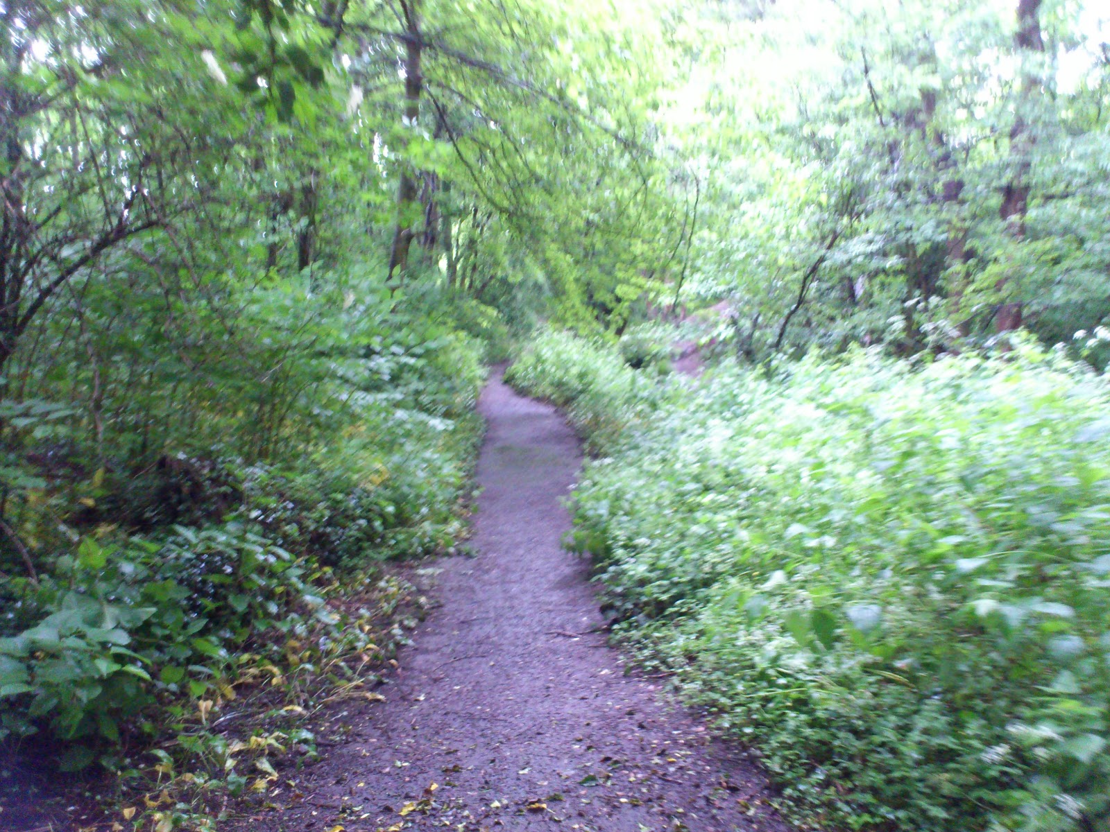
There are two paths to walk; one is tarmacked and is a continuation of the Daffodil Walk. The other is muddy and very overgrown, but more fun! I walked the ‘cleaner’ path, but diverted to the mud path to get photos. They both start in approximately the same place, and end near each other too. You can either cycle down Mill Lane, or along the path through the woodland.


I didn’t know until a short while ago that there was actually a mill on this river, and I also didn’t know that there are some remains of it left, although they are buried by the plants here. This notice board needs a clean but you may be able to work out some of what it says. The quote in the middle is from a poem called Ode To A Secret River. The notice board is off the tarmacked track - I came upon a fork in the road and turned right. This path was slightly muddier, and has some steps. It is down these steps that the notice board can be found, and the end of the route is in sight.


This is another really nice walk in the ‘burbs. It doesn’t really take you anywhere important, but it makes a change from the standard footpath walk. It is a good place to escape from the bustle of life. It was so peaceful down by the river, I could've stayed there for a while.


There are a lot more photos on the Flickr site, I took quite a few! Some are blurry because I was taking them on my phone as I was walking.

This route is close to public transport links and there is no parking available. It is also near a residential area – please respect this. Also, please remember to take your rubbish with you – there are only one or two bins. This is a wildlife corridor, and there is a river running through it. If you have kids, be mindful of this. Also, the banks can be very slippy after rainfall. When I walked this route, the river was in flood, and although not deep it was going quite fast. The end of this walk is a busy traffic junction with 4-way signals, and no crossing. Please take care crossing here!!

You can get here by train, on the cross-city line to Northfield – this screengrab from Google Earth shows two ways to get here, depending on which platform you alight at.


You can also get the bus. The 27 from Kings Heath/Maypole stops on Abbeydale Road (where the 'Google' is on the pic) near Coleys Lane. Walk down Coleys towards the bridge. Follow the white line under the bridge, the entrance to this walk route is on the left. Take care when crossing here. You can also walk this route as a continuation of the Daffodil Park walk, which is what I did.

L x


Pics were taken by me, June 7th. Feel free to nick 'em. More pics here.